Syr Darya Modelling |
|||
|
|
|||
| Team: Silvio Pereira Cardenal , Peter Bauer-Gottwein, Claire Michailovsky, Niels Riegels, Michael Butts | |||
|
|||
|
The potential of radar altimetry data to constrain and inform a regional scale hydrological model of the Syr Darya river basin (SDRB) is evaluated. In-situ monitoring in the SDRB is sparse and suffers from mutual distrust between the riparian countries, which have conflicting objectives for the operation of storage, hydropower, and irrigation facilities in the basin. Within the SDRB, about 75 suitable altimetry targets from both ERS-2 and Envisat satellites are available. This study focuses on the satellite altimetry time series over man-made reservoirs and natural lakes. The study demonstrates that the predictive capability of a hydrological river basin model of the SDRB can be significantly improved if radar altimetry data are assimilated into the model and lake and reservoir levels are updated in real time. |
|||
Figure 1: Syr Darya River System and available altimetry targets.
|
|||
Figure 2: Comparison between altimetry and in-situ water levels for the Syr Darya system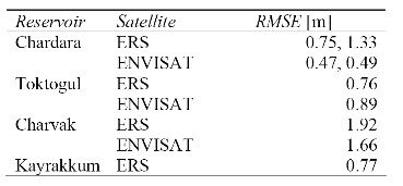
|
|||
Figure 3: Real-time modeling results
|
|||
|
Blue: Observed in-situ WL Red: Open loop simulation (no assimilation) Black: Assimilation of altimetry Black crosses: Altimetry data Grey halo: Ensemble spread |
|||